
Colorado Loop – August 2020
Still giving a big ![]() to viral tyranny, we pointed our vans northeast to Colorado.
to viral tyranny, we pointed our vans northeast to Colorado.
![]() Prescott, AZ to Goosenecks, UT:
Left from Mom & Dad's place and ventured to our usual southeast Utah camp spot at Goosenecks State Park.
Prescott, AZ to Goosenecks, UT:
Left from Mom & Dad's place and ventured to our usual southeast Utah camp spot at Goosenecks State Park.


![]() Goosenecks, UT to West Dolores River, CO: After spending time looking down into the curvy canyon carved by the San Juan River and chatting with a local Navajo, we were off to Colorado.
But the question was, to where? At a gas stop in Cortez, we pulled out the Colorado recreation atlas to peruse options. With the sun not getting any higher in the sky, we had to find a place somewhat nearby. There appeared to be campgrounds up highway 145 along the West Dolores River. Upon arriving at the turn, we saw
that the road was open, so rolled the dice. The two federal campgrounds were full, but the nice hosts at the second location told us about a forest service boondocking spot up the river on the right side of the road. We passed a few potential spots, finally arriving at a closed gate and dirt road. Backtracking just a bit, we turned into a place
with a large area that a Sprinter van had just parked in. Perfect! 37.707386, -108.246505
Goosenecks, UT to West Dolores River, CO: After spending time looking down into the curvy canyon carved by the San Juan River and chatting with a local Navajo, we were off to Colorado.
But the question was, to where? At a gas stop in Cortez, we pulled out the Colorado recreation atlas to peruse options. With the sun not getting any higher in the sky, we had to find a place somewhat nearby. There appeared to be campgrounds up highway 145 along the West Dolores River. Upon arriving at the turn, we saw
that the road was open, so rolled the dice. The two federal campgrounds were full, but the nice hosts at the second location told us about a forest service boondocking spot up the river on the right side of the road. We passed a few potential spots, finally arriving at a closed gate and dirt road. Backtracking just a bit, we turned into a place
with a large area that a Sprinter van had just parked in. Perfect! 37.707386, -108.246505


After dinner, I climbed up into the loft, drifting off to sleep to the soothing sounds of river riffles.
![]() West Dolores River to Big Bear Creek:
Woke up to happy birds chirping. Opening the tent windows provided a wonderful view of the beautiful natural surroundings. While having a leisurely breakfast,
and basking in the warmth of the sun, we considered staying another night.
West Dolores River to Big Bear Creek:
Woke up to happy birds chirping. Opening the tent windows provided a wonderful view of the beautiful natural surroundings. While having a leisurely breakfast,
and basking in the warmth of the sun, we considered staying another night.


Seeing storm clouds building, we ultimately opted to drive onward. Will definitely return to this spot in the future!
Arriving in the old mining town of Rico, we stopped to take in the sights of this historic place.


En route to Telluride, couldn't help but pull off to take photos of the gorgeous landscape.


Telluride: Just like Sedona in my home state, this town is a tourist trap! There was zero parking to be found in the actual town proper. Driving out to the Bridal Veil Falls parking area found it to be full too! Thinking we were out of luck, we began driving back out when a couple of cars left their spots along the road in front the massive Pandora Mill. We ate lunch and set about exploring a bit.


With the sun getting lower in the sky, we set about finding a place to camp for the night. Just a few miles down Highway 145 we found another boondocking spot along Big Bear Creek. While eating dinner, it was painfully obvious that this, despite being dirt, was a popular thoroughfare! For safety, I put out my collapsible cone behind the van. Didn't get much sleep thanks in large part to all of the traffic.


![]() Big Bear Creek to Crawford State Park:
We were up and off early given the traffic volume. Where to venture to today? Up and over the mountains to Ridgway via Highway 62, then to Blue Mesa Reservoir with a stop at
Black Canyon of the Gunnison N.P. The national park was open only to pass-through visitation* (no camping, no visitor center access, etc.). We stopped at just a couple of vistas
drove on, crossing the Blue Mesa Reservoir dam to see the grand views from the north side of the canyon.
Big Bear Creek to Crawford State Park:
We were up and off early given the traffic volume. Where to venture to today? Up and over the mountains to Ridgway via Highway 62, then to Blue Mesa Reservoir with a stop at
Black Canyon of the Gunnison N.P. The national park was open only to pass-through visitation* (no camping, no visitor center access, etc.). We stopped at just a couple of vistas
drove on, crossing the Blue Mesa Reservoir dam to see the grand views from the north side of the canyon.


* Fortunately, we had toured this park, and even camped down at the river, back in 2009 when doing a big loop through Colorado, Wyoming, Utah in Dad's pick-up truck.
![]() Crawford State Park to Rifle Gap State Park:
Chatting with a kind couple at the campground, we found out that singer Joe Cocker's final resting place was up the road in the town of Crawford. While the lake was quite low, the surroundings were beautiful.
Crawford State Park to Rifle Gap State Park:
Chatting with a kind couple at the campground, we found out that singer Joe Cocker's final resting place was up the road in the town of Crawford. While the lake was quite low, the surroundings were beautiful.


Next on the itinerary was Glendwood Springs so that I could finally see Doc Holliday's gravesite. After finding a place to park (not much available being in a residential neighborhood), Dad & I hiked up the road to
the cemetery. While perusing those of yesteryear, I couldn't help but notice a massive plume of smoke rising up behind the mountain.![]()


After leaving Doc Holliday, we slowly made our way in traffic to a gas station. While filling the vans and getting ice for our cups, I couldn't help but notice that there were "road closed" signs. With a fire clearly building on the other side of the mountains, I decided it would be prudent to whip out the cell phone to see what was going on. Our plan to go to Steamboat Springs via I-70 was out of the question: the highway was closed east of Glenwood Springs due to the fire and a landslide. So, time for Plan B: head northwest instead! But where to camp for the night? In looking at the atlas, we saw a couple of options, one being Rifle Falls. Being a state park, a site had to be procured via Colorado's state parks web site. In driving into the park via a long, winding road, I couldn't help but think that this could be a problem if the wind changes direction on any of the fires.
The campsite chosen wasn't the best, but it worked.

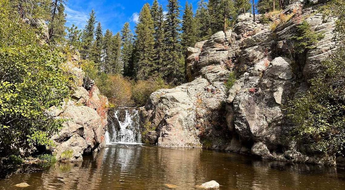
![]() Rifle Falls to Steamboat Lake:
After breakfast, we packed the vans and drove up to the trailhead parking area (short distance, but didn't want to risk overstaying beyond checkout time), and walked to the beautiful waterfalls.
Rifle Falls to Steamboat Lake:
After breakfast, we packed the vans and drove up to the trailhead parking area (short distance, but didn't want to risk overstaying beyond checkout time), and walked to the beautiful waterfalls.


Leaving Rifle Falls, we headed north on Highway 13 to Craig. Two issues occurred: 1) fire smoke followed us almost the whole way ![]() , 2) at one point I looked in the mirror to find Old Gray missing.
Calling on the two-way radio returned silence and no response on the phone. On this two-way highway with traffic behind me, there were few safe places to pull off large enough for two vans. Seeing a town, Hamilton, up ahead on the GPS, I stopped there.
Eventually, parents pulled in behind me: the pop-top had come unlatched and flew up
, 2) at one point I looked in the mirror to find Old Gray missing.
Calling on the two-way radio returned silence and no response on the phone. On this two-way highway with traffic behind me, there were few safe places to pull off large enough for two vans. Seeing a town, Hamilton, up ahead on the GPS, I stopped there.
Eventually, parents pulled in behind me: the pop-top had come unlatched and flew up ![]() , so they had pulled over to secure it.
, so they had pulled over to secure it.
We ventured on to Craig where we stopped for lunch and made a call to one of Mom's oldest friends (lives in Steamboat), who, sadly - if not maddeningly - brushed her off because she was busy with other friends.![]() With that, we drove up to Steamboat Lake State Park for the night where, amazingly, there were just a few sites available.
With that, we drove up to Steamboat Lake State Park for the night where, amazingly, there were just a few sites available.

After walking around the campground (spotted another Orly Blue Westy, albeit in poor shape), I was relaxing in the van at dusk when I heard a loud <clunk!>. Going out to investigate, I found two teenagers walking away to the neighboring campsite carrying a Frisbee. They said, "Sorry", and I responded with, "Don't let it happen again", as they continued to toss the Frisbee in the space between the sites. The fat ass loafing on the rear deck of his new (hideous) RV proceded to chew me out for not being nice enough to his kids/grandkids, adding in a snide, "It's just a Frisbee; it can't hurt anything; let the kids have some fun." I had to restrain my anger in discussing the issue... I wanted to get my own Frisbee out at about 2am and toss it hard into that RV, but I refrained. The next morning, bright and early, they left. Wonder why...?
![]() Steamboat Lake to Clear Creek:
In cleaning the van after breakfast, I was able to inspect the Frisbee hit closer in the bright daylight: Fortunately, there was no dent, but there were scratches, which would most likely buff out, but not until getting home.
Steamboat Lake to Clear Creek:
In cleaning the van after breakfast, I was able to inspect the Frisbee hit closer in the bright daylight: Fortunately, there was no dent, but there were scratches, which would most likely buff out, but not until getting home.
After taking a look at Steamboat Lake, we ventured southward, smoke following us all the way to Wolcott. After gassing up, we decided to go up and over the mountains via Highway 24.

We attempted to camp at Turqouise Lake, but both campgrounds were full. Driving on, we then attempted to stop at Twin Lakes, or perhaps forest service camps, but, due to the fire, the road going to the lakes and, ultimately, Aspen was closed. So, onward we drove, hoping to find something. Eventually, we came upon Clear Creek. While the road going in there was lousy, it turned out to be a fantastic boondocking area, especially since the smoke stayed to the north. Definitely need to return to this place, hopefully, getting the site right next to the creek!


![]() Clear Creek to Mt. Blanca:
Driving south, we stopped in at Great Sand Dunes National Park. Mom needed an extended break, but being delayed by road construction, put us behind, so I drove on ahead
to the park. Seeing that the gift shop was, amazingly, open (albeit through a glass window
Clear Creek to Mt. Blanca:
Driving south, we stopped in at Great Sand Dunes National Park. Mom needed an extended break, but being delayed by road construction, put us behind, so I drove on ahead
to the park. Seeing that the gift shop was, amazingly, open (albeit through a glass window ![]() ), I went there first,
since it was nearing closing time and there was a line. After buying stickers and books, Mom and Dad arrived in time to visit the dunes, where shadows were beginning to
dance across the sand.
), I went there first,
since it was nearing closing time and there was a line. After buying stickers and books, Mom and Dad arrived in time to visit the dunes, where shadows were beginning to
dance across the sand.


As the sun was beginning to set, we had to find a place for the night. In looking at the atlas, it showed boondocking just south, at Mt. Blanca. Sure enough, lots of free camping areas. It's also a well-used road for four-wheelers going up into the Sangre De Cristo Wilderness, which we saw late into the night via their headlights.


![]() Mt. Blanca to near Jemez River, NM:
It didn't take long before we crossed into New Mexico. We stopped in Taos for lunch where I spied a burgundy Westy across the street. While eating, we studied the atlas as to
where to venture to next. We decided to go up to the Valles Caldera, where all of the federal campgrounds were closed.
Mt. Blanca to near Jemez River, NM:
It didn't take long before we crossed into New Mexico. We stopped in Taos for lunch where I spied a burgundy Westy across the street. While eating, we studied the atlas as to
where to venture to next. We decided to go up to the Valles Caldera, where all of the federal campgrounds were closed. ![]()


After stopping to take in the grand vistas while the sun was going down, we drove on, hoping to find a place to camp. We eventually came upon an ungated boondock area, directly above Spence Hot Springs, and there was a spot available, albeit on a hill, near the entrance.

![]() Near Jemez River, NM to Sawtooth Mountains, NM:
Woke up early thanks to traffic, both on the highway and in the campground. It was a quick breakfast due to lightning and thunder approaching.
Near Jemez River, NM to Sawtooth Mountains, NM:
Woke up early thanks to traffic, both on the highway and in the campground. It was a quick breakfast due to lightning and thunder approaching.
Beautiful drive down through the canyon, Jemez Pueblo, and Jemez Springs. There were a lot of travellers out, thus no opportunities to stop and take photos, so wonderful photos from others are posted below. Will definitely need to return to the area someday to do some exploring.


Still heading south, we stopped for gas in Albuquerque, then continued down Highway 25. I wanted to avoid I-40 due to a) the wind (it was blowing pretty hard at this point), 2) to continue seeing country we haven't seen before. Dad wasn't sold on the route, but by the time we arrived back in Arizona, his mind had been thoroughly changed.
After stopping in Socorro for more fuel, we headed west on Highway 60. Just beyond the town of Magdalena, Highway 60 turned into the flattest, straightest, least travelled (no traffic) 2-lane road we've ever been on. Turned out, Dad & I both had the same thought:
excellent for doing speed runs in high-performance cars! It also where The Very Large Array is located,
which was closed due to the federal lockdown. ![]()
After about 40 miles and another federal campground being closed, we pressed on looking for a forest service road to boondock off of - with the sun setting, we didn't want to have to be searching in uncharted (to us) territory in pitch black. Passing several potential options, finally turned on FS 6a and found a perfect spot, which cattle like to enjoy as well, considering a small herd came sauntering through as we were setting up. There was a prediction of rain, so we installed our DIY rainflies. 34.273884, -107.982023


![]() Sawtooth Mountains, NM to Show Low Lake, AZ:
Turned out, we needn't have bothered putting the rainflies on because it didn't rain; didn't even drizzle! But it was a gorgeous day for a drive - blue sky and wildflowers galore!
Sawtooth Mountains, NM to Show Low Lake, AZ:
Turned out, we needn't have bothered putting the rainflies on because it didn't rain; didn't even drizzle! But it was a gorgeous day for a drive - blue sky and wildflowers galore!


Leaving Springerville, we took AZ 260 west, stopping in Pinetop-Lakeside for lunch. While there, we looked at the atlas one last time for a place to stay for the night. We decided on Show Low Lake, which had plenty of sites to choose from. After boondocking for a week, we opted for a plug-in site. After setting up camp, we walked across the road to take a look at the lake.


![]() Show Low Lake, AZ to home:
Left Show Low for the 4-hour drive home. Fabulous trip!
Show Low Lake, AZ to home:
Left Show Low for the 4-hour drive home. Fabulous trip!
Total miles: 2,221
Average MPG: 20.19
Updated: 1-Jan-2024